Stockport
§ This page gives an overview of the Stockport local authority district, bringing together key facts, maps, and data to help you quickly understand the area. This is one of 361 LAD profiles on Baseview.
Overview ⁞ Stockport, south-east of Manchester, is known for its striking Viaduct, a massive railway bridge dominating the town centre. The River Mersey begins here at the confluence of the Goyt and Tame, with the town surrounded by valleys and wooded areas. Landmarks include Staircase House, the Hat Works Museum, and Bramall Hall, a Tudor manor in parkland. Suburban villages such as Marple and Bramhall provide leafy residential areas, while the edge of the Peak District offers dramatic landscapes nearby.
What County is Stockport in?
Stockport is in Greater Manchester, in North West England. It is administered by Stockport Metropolitan Borough Council, which operates as a metropolitan borough and unitary authority. For modern administrative, geographic, and ceremonial purposes, Stockport is officially part of Greater Manchester rather than a traditional English county.
Historically, Stockport was part of the county of Cheshire before local government reforms in 1974 created the metropolitan county of Greater Manchester. This historic link explains why some older records and informal references may still associate Stockport with Cheshire. However, since these boundary changes, Stockport has been in Greater Manchester, which remains the correct and current answer today.
Stockport Boundary Map
This map shows the official boundary of the Stockport local authority district, based on the latest geographic data published by the Office for National Statistics (ONS). It provides a clear view of the district’s extent and helps you understand how the area fits within the wider regional and national landscape.
Contains OS data © Crown copyright and database right 2025. Source: Office for National Statistics licensed under the Open Government Licence v3.0.
The administrative boundary of Stockport can also be viewed on OpenStreetMap: District Boundary of Stockport.
Key Facts about Stockport
What region is Stockport in? Stockport is in the North West of England, a region within the UK.
What county is Stockport in? Stockport is located in the county of Greater Manchester.
Is Stockport a city? No, Stockport is not a city. (Note: the UK has 76 officially designated cities.)
Who governs Stockport? The local government for this district is: Stockport Borough Council (Metropolitan District).
▶ Official website of Stockport Borough Council 🔗 stockport.gov.uk
Which police force covers Stockport? Policing in Stockport is provided by Greater Manchester Police 🔗 gmp.police.uk, which serves 10 local authority districts: Bolton ⁞ Bury ⁞ Manchester ⁞ Oldham ⁞ Rochdale ⁞ Salford ⁞ Stockport ⁞ Tameside ⁞ Trafford ⁞ Wigan.
Constituencies in Stockport
Stockport is divided into 3 parliamentary constituencies, listed below in alphabetical order.
A constituency is a specific geographical area that elects one Member of Parliament (MP) to represent them in the House of Commons. The United Kingdom is divided into 650 parliamentary constituencies. We have this list page for easy browsing of all UK parliamentary constituencies: List of Constituencies.
Wards in Stockport
Stockport is divided into 21 wards, listed below in alphabetical order.
- Bramhall North
- Bramhall South & Woodford
- Bredbury & Woodley
- Bredbury Green & Romiley
- Brinnington & Stockport Central
- Cheadle East & Cheadle Hulme North
- Cheadle Hulme South
- Cheadle West & Gatley
- Davenport & Cale Green
- Edgeley
- Hazel Grove
- Heald Green
- Heatons North
- Heatons South
- Manor
- Marple North
- Marple South & High Lane
- Norbury & Woodsmoor
- Offerton
- Reddish North
- Reddish South
In the UK, a ward is a subdivision of a local authority area, used mainly for electoral and statistical purposes. Defined by the ONS, wards represent the primary unit for local elections, each returning one or more councillors to the local council. Wards are also used as a key geography for presenting population and census data. We have this list page for easy browsing of all electoral wards: List of all Electoral Wards in the UK.
Parishes in Stockport
Stockport is entirely unparished—there are no civil parishes in this local authority district.
Parishes are the lowest tier of local government; where they don’t exist, those very local services and representation sit directly with the principal council. We have this list page for easy browsing of all parishes: List of Civil Parishes in England and Wales.
Post Towns in Stockport
Below is a list of post towns in Stockport, grouped by postcode area:
- SK ▸ Cheadle (SK8) ⁞ Stockport (SK1 / SK2 / SK3 / SK4 / SK5 / SK6 / SK7 / SK12)
The UK postal hierarchy begins with broad postcode areas (such as “CB” or “M”), which are divided into smaller postcode districts (such as “CB8” or “M1”) to support accurate mail routing. Each postal address is anchored by a designated post town, the official locality name used in the UK postcode system, which operates independently from Local Authority Districts —the administrative boundaries used for council tax and local government services. Because they serve different purposes, a property’s postal address and its local authority district do not always align exactly.
Built-up Areas in Stockport
Stockport covers 19 built-up areas, listed below in alphabetical order.
- Bramhall
- Bredbury and Woodley *
- Cheadle (Stockport)
- Cheadle Hulme
- Denton (Tameside) *
- Gatley *
- Hazel Grove *
- High Lane *
- Hyde (Tameside) *
- Manchester *
- Marple
- Marple Bridge
- Marpleridge *
- Poynton *
- Reddish *
- Romiley
- Stockport *
- Woodford (Stockport) *
- Wythenshawe *
In the UK, a Built-up Area (BUA) is a continuous urban area of at least 20 hectares (0.2 km²), defined by the ONS as land where buildings are generally no more than 200 metres apart, such as towns, cities, or large villages. (Note: A BUA name marked with an asterisk (*) indicates that the area is situated partly in the district of Stockport.)
We have this list page for easy browsing of all built-up areas: List of all Built-up Areas in GB.
Railway Stations in Stockport
Stockport is served by a number of National Rail stations, providing rail connections to nearby towns, cities, and destinations across Great Britain. The railway stations listed below are located within the Stockport Local Authority District and are grouped by train operating company for clarity.
- Avanti West Coast ▸ Stockport (SK3 9HZ)
- Northern Trains ▸ Cheadle Hulme (SK8 5AF) ⁞ Heaton Chapel (SK4 4NX) ⁞ Hazel Grove (SK7 4EX) ⁞ Heald Green (SK8 3DY) ⁞ Gatley (SK8 4AE) ⁞ Marple (SK6 7DA) ⁞ Davenport (SK3 8SA) ⁞ Romiley (SK6 4BN) ⁞ Woodsmoor (SK2 7DW) ⁞ Bramhall (SK7 2DU) ⁞ Bredbury (SK6 2AA) ⁞ Reddish North (SK5 6RS) ⁞ Rose Hill Marple (SK6 6EE) ⁞ Brinnington (SK5 8JE) ⁞ Woodley (SK6 1NX) ⁞ Middlewood (SK6 8AU) ⁞ Reddish South (SK5 6TU)
This is a district-level view only. For a complete list of all National Rail stations across Great Britain, see the UK National Rail Stations Directory.
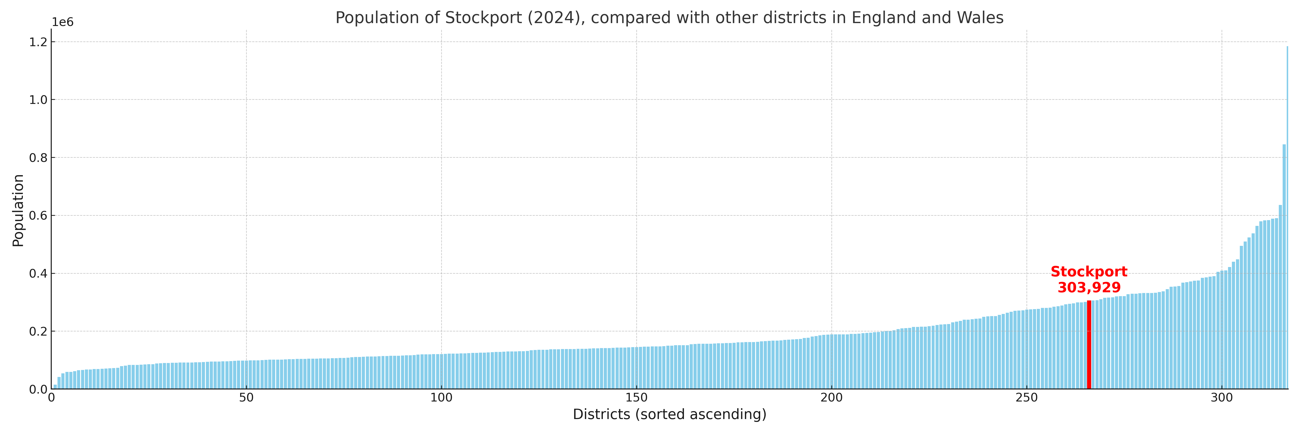
Stockport compared with other districts in the UK
This section shows how Stockport compares with other local authority districts in the UK, using a variety of measures and rankings.
Stockport has 21 electoral wards.

Stockport has a population of 303,929 (2024 mid-year estimate by ONS)
Population and Migration Trends in Stockport
This chart shows the population trend for Stockport from 2015 to 2024. It provides a quick overview of whether the local authority is growing, stable, or declining over time, and helps set context for the migration patterns shown below.
Population change is influenced by natural change (births minus deaths) and migration. The net migration chart below focuses on migration, separating internal migration (moves within the UK) from international migration (moves to and from abroad). Positive values indicate net inflows, while negative values indicate net outflows. The rate labels (per 1,000 residents) help compare migration intensity across years, even when the population size changes.
More local statistics and data for Stockport can be found on the ONS statistics for Stockport.
Latest news about Stockport
Use the search box, or suggested search phrases, below to find recent news, council updates, planning stories, housing developments, transport changes, public services news, local elections, community issues and other local developments related to Stockport. Results may include coverage from UK national, regional and local news websites, as well as official public-sector and local democracy sources.
- Stockport council
- Stockport planning
- Stockport local elections
- Stockport housing
- Stockport transport
- Stockport regeneration
- Stockport public services