County Durham
§ This page gives an overview of the County Durham local authority district, bringing together key facts, maps, and data to help you quickly understand the area. This is one of 361 LAD profiles on Baseview.
Overview ⁞ County Durham is a historic and diverse ceremonial county stretching from the North Pennines in the west to the North Sea coast in the east. Its centrepiece is the city of Durham, renowned for its UNESCO-listed cathedral and castle, while the wider county includes former coal-mining towns such as Bishop Auckland and Consett, as well as coastal communities like Seaham and Hartlepool. The area was central to England’s industrial and railway heritage, particularly during the 19th century. Today, the ceremonial county includes three unitary authorities: Durham County Council, which covers the majority of the area; the Borough of Darlington; and Hartlepool Borough Council—both of which are administratively independent but fall within County Durham for ceremonial purposes.
County Durham Boundary Map
This map shows the official boundary of the County Durham local authority district, based on the latest geographic data published by the Office for National Statistics (ONS). It provides a clear view of the district’s extent and helps you understand how the area fits within the wider regional and national landscape.
Contains OS data © Crown copyright and database right 2025. Source: Office for National Statistics licensed under the Open Government Licence v3.0.
The administrative boundary of County Durham can also be viewed on OpenStreetMap: District Boundary of County Durham.
Key Facts about County Durham
What region is County Durham in? County Durham is in the North East of England, a region within the UK.
What county is County Durham in? County Durham is in the county of County Durham.
Is County Durham a city? Yes, County Durham is a city. County Durham holds official city status as one of the 76 designated cities in the UK.
Who governs County Durham? The local government for this district is: Durham County Council (Unitary Authority).
▶ Official website of Durham County Council 🔗 durham.gov.uk

Which police force covers County Durham? Policing in County Durham is provided by Durham Constabulary 🔗 durham.police.uk, which serves 2 local authority districts: County Durham ⁞ Darlington.
Constituencies in County Durham
County Durham is divided into 6 parliamentary constituencies, listed below in alphabetical order.
- Bishop Auckland
- Blaydon and Consett
- City of Durham
- Easington
- Newton Aycliffe and Spennymoor
- North Durham
A constituency is a specific geographical area that elects one Member of Parliament (MP) to represent them in the House of Commons. The United Kingdom is divided into 650 parliamentary constituencies. We have this list page for easy browsing of all UK parliamentary constituencies: List of Constituencies.
Wards in County Durham
County Durham is divided into 63 wards, listed below in alphabetical order.
- Annfield Plain
- Aycliffe East
- Aycliffe North and Middridge
- Aycliffe West
- Barnard Castle East
- Barnard Castle West
- Belmont
- Benfieldside
- Bishop Auckland Town
- Bishop Middleham and Cornforth
- Blackhalls
- Brandon
- Burnopfield and Dipton
- Chester-le-Street East
- Chester-le-Street North
- Chester-le-Street South
- Chester-le-Street West Central
- Chilton
- Consett North
- Consett South
- Coundon
- Coxhoe
- Craghead and South Moor
- Crook
- Dawdon
- Deerness
- Delves Lane
- Deneside
- Durham South
- Easington
- Elvet and Gilesgate
- Esh and Witton Gilbert
- Evenwood
- Ferryhill
- Framwellgate and Newton Hall
- Horden
- Lanchester
- Leadgate and Medomsley
- Lumley
- Murton
- Neville's Cross
- North Lodge
- Passfield
- Pelton
- Peterlee East
- Peterlee West
- Sacriston
- Seaham
- Sedgefield
- Sherburn
- Shildon and Dene Valley
- Shotton and South Hetton
- Spennymoor
- Stanley
- Tanfield
- Tow Law
- Trimdon and Thornley
- Tudhoe
- Weardale
- West Auckland
- Willington and Hunwick
- Wingate
- Woodhouse Close
In the UK, a ward is a subdivision of a local authority area, used mainly for electoral and statistical purposes. Defined by the ONS, wards represent the primary unit for local elections, each returning one or more councillors to the local council. Wards are also used as a key geography for presenting population and census data. We have this list page for easy browsing of all electoral wards: List of all Electoral Wards in the UK.
Parishes in County Durham
County Durham is part-parished: 136 civil parishes (listed A-Z below) alongside 8 unparished areas.
- Barforth
- Barnard Castle
- Barningham
- Bearpark
- Belmont
- Bishop Auckland
- Bishop Middleham
- Bolam
- Boldron
- Bournmoor
- Bowes
- Bradbury and the Isle
- Brancepeth
- Brandon and Byshottles
- Brignall
- Burnhope
- Cassop-cum-Quarrington
- Castle Eden
- Chilton
- City of Durham
- Cleatlam
- Cockfield
- Cornforth
- Cornsay
- Cotherstone
- Coxhoe
- Croxdale and Hett
- Dalton-le-Dale
- Dene Valley
- Easington Colliery
- Easington Village
- Edmondbyers
- Edmondsley
- Eggleston
- Egglestone Abbey
- Eldon
- Esh
- Etherley
- Evenwood and Barony
- Ferryhill
- Fishburn
- Forest and Frith
- Framwellgate Moor
- Gainford
- Gilmonby
- Great Aycliffe
- Great Lumley
- Greater Willington
- Greencroft
- Hamsterley
- Haswell
- Hawthorn
- Headlam
- Healeyfield
- Hedleyhope
- Hilton
- Holwick
- Hope
- Horden
- Hunderthwaite
- Hunstanworth
- Hutton Henry and Station Town
- Hutton Magna
- Ingleton
- Kelloe
- Kimblesworth and Plawsworth
- Lanchester
- Lands Common to Brancepeth and Brandon and Byshottles
- Lands common to Hamsterley, Lynesack and Softley and South Bedburn
- Langleydale and Shotton
- Langton
- Lartington
- Little Lumley
- Lunedale
- Lynesack and Softley
- Marwood
- Mickleton
- Middleton in Teesdale
- Middridge
- Monk Hesleden
- Mordon
- Morton Tinmouth
- Muggleswick
- Murton
- Nesbitt
- Newbiggin
- North Lodge
- Ouston
- Ovington
- Pelton
- Peterlee
- Pittington
- Raby with Keverstone
- Rokeby
- Romaldkirk
- Sacriston
- Satley
- Scargill
- Seaham
- Seaton with Slingley
- Sedgefield
- Shadforth
- Sheraton with Hulam
- Sherburn Village
- Shildon
- Shincliffe
- Shotton
- South Bedburn
- South Hetton
- Spennymoor
- Staindrop
- Stanhope
- Stanley
- Startforth
- Streatlam and Stainton
- Thornley
- Tow Law
- Trimdon
- Trimdon Foundry
- Urpeth
- Wackerfield
- Waldridge
- West Auckland
- West Rainton and Leamside
- Westwick
- Wheatley Hill
- Whorlton
- Windlestone
- Wingate
- Winston
- Witton Gilbert
- Witton-le-Wear
- Wolsingham
- Wolsingham Park Moor lands cmn to Stanhope, Tow Law and Wolsingham
- Woodland
- Wycliffe with Thorpe
A civil parish is the lowest tier of local government in England, used for villages, small towns, and suburbs. They have their own local authority, either a parish council or a parish meeting, which provides local services like managing parks, allotments, and streetlights, and represents the community's views to larger councils.
We have this list page for easy browsing of all parishes: List of Civil Parishes in England and Wales.
Post Towns in County Durham
Below is a list of post towns in County Durham, grouped by postcode area:
- DH ▸ Chester le Street (DH2 / DH3) ⁞ Consett (DH8) ⁞ Durham (DH1 / DH6 / DH7 / DH8 / DH97 / DH98 / DH99) ⁞ Stanley (DH8 / DH9)
- DL ▸ Barnard Castle (DL12) ⁞ Bishop Auckland (DL13 / DL14) ⁞ Crook (DL15) ⁞ Ferryhill (DL16 / DL17) ⁞ Newton Aycliffe (DL5) ⁞ Shildon (DL4) ⁞ Spennymoor (DL16)
- SR ▸ Peterlee (SR8) ⁞ Seaham (SR7)
- TS ▸ Trimdon Station (TS29) ⁞ Wingate (TS28)
The UK postal hierarchy begins with broad postcode areas (such as “CB” or “M”), which are divided into smaller postcode districts (such as “CB8” or “M1”) to support accurate mail routing. Each postal address is anchored by a designated post town, the official locality name used in the UK postcode system, which operates independently from Local Authority Districts —the administrative boundaries used for council tax and local government services. Because they serve different purposes, a property’s postal address and its local authority district do not always align exactly.
Built-up Areas in County Durham
County Durham covers 106 built-up areas, listed below in alphabetical order.
- Annfield Plain
- Barnard Castle
- Beamish
- Billy Row
- Birtley *
- Bishop Auckland
- Bishop Middleham
- Blackhall Colliery
- Blackhall Mill *
- Blackhall Rocks
- Bournmoor
- Bowburn
- Brandon (County Durham)
- Burnhope
- Burnopfield
- Byers Green
- Castleside
- Chester-le-Street *
- Chilton (County Durham)
- Cockfield
- Consett *
- Cornforth
- Cotherstone
- Coundon and Leeholme
- Coxhoe
- Craghead
- Crook
- Croxdale
- Dipton
- Durham
- Easington (County Durham)
- Eastgate
- Ebchester
- Eldon Lane and Coundon Grange
- Esh Winning
- Evenwood
- Fence Houses *
- Ferryhill
- Fishburn
- Frosterley
- Gainford
- Great Lumley
- Hamsterley
- Hamsterley Mill
- Haswell
- Hetton le Hill
- High Pittington
- High Shincliffe
- Hilton (Eden) *
- Hobson
- Horden
- Hunwick
- Kelloe
- Kirk Merrington
- Lanchester
- Langley Park
- Leadgate
- Medomsley
- Mickleton (County Durham)
- Middleton-in-Teesdale
- Murton (County Durham)
- Nettlesworth and Kimblesworth
- New Brancepeth
- Newfield
- Newton Aycliffe *
- Pelton and Ouston
- Peterlee
- Rowlands Gill *
- Sacriston
- School Aycliffe *
- Seaham
- Sedgefield
- Shadforth
- Sherburn (County Durham)
- Sherburn Hill
- Shildon *
- Shotton Colliery
- South Hetton *
- Spennymoor
- Staindrop
- Stanhope
- Stanley (County Durham)
- Startforth
- Tanfield Lea
- Tantobie
- Thornley
- Toft Hill and High Etherley
- Tow Law
- Trimdon
- Trimdon Colliery
- Trimdon Grange
- Urpeth
- Ushaw Moor and Bearpark
- Washington *
- West Auckland
- West Pelton
- West Rainton *
- Wheatley Hill
- Whitehill (County Durham)
- Willington (County Durham)
- Wingate
- Witton Gilbert
- Witton Park
- Witton-le-Wear
- Wolsingham
- Wynyard *
In the UK, a Built-up Area (BUA) is a continuous urban area of at least 20 hectares (0.2 km²), defined by the ONS as land where buildings are generally no more than 200 metres apart, such as towns, cities, or large villages. (Note: A BUA name marked with an asterisk (*) indicates that the area is situated partly in the district of County Durham.)
We have this list page for easy browsing of all built-up areas: List of all Built-up Areas in GB.
Railway Stations in County Durham
County Durham is served by a number of National Rail stations, providing rail connections to nearby towns, cities, and destinations across Great Britain. The railway stations listed below are located within the County Durham Local Authority District and are grouped by train operating company for clarity.
- London North Eastern Railway ▸ Durham (DH1 4RB)
- Northern Trains ▸ Chester-Le-Street (DH3 3EE) ⁞ Bishop Auckland (DL14 7EJ) ⁞ Seaham (SR7 0XX) ⁞ Horden (SR8 4EA) ⁞ Newton Aycliffe (DL5 7BG) ⁞ Shildon (DL4 1LX) ⁞ Heighington (DL5 6PX)
This is a district-level view only. For a complete list of all National Rail stations across Great Britain, see the UK National Rail Stations Directory.
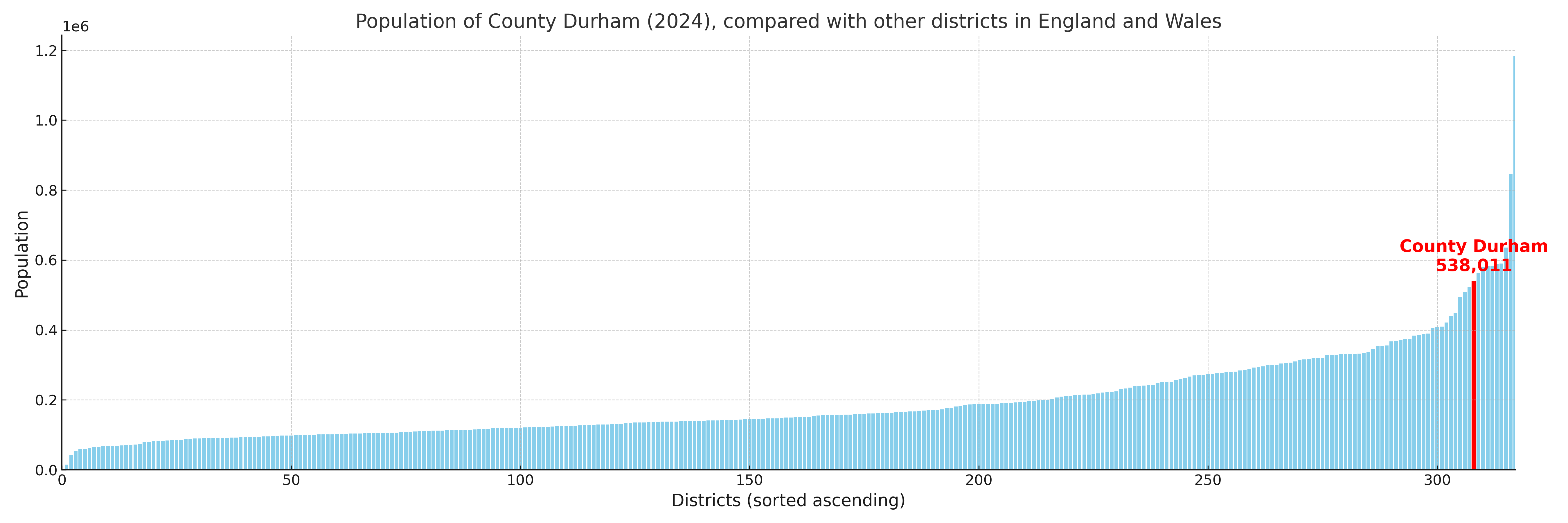
County Durham compared with other districts in the UK
This section shows how County Durham compares with other local authority districts in the UK, using a variety of measures and rankings.
County Durham has 63 electoral wards.

County Durham has a population of 538,011 (2024 mid-year estimate by ONS)
Population and Migration Trends in County Durham
This chart shows the population trend for County Durham from 2015 to 2024. It provides a quick overview of whether the local authority is growing, stable, or declining over time, and helps set context for the migration patterns shown below.
Population change is influenced by natural change (births minus deaths) and migration. The net migration chart below focuses on migration, separating internal migration (moves within the UK) from international migration (moves to and from abroad). Positive values indicate net inflows, while negative values indicate net outflows. The rate labels (per 1,000 residents) help compare migration intensity across years, even when the population size changes.
More local statistics and data for County Durham can be found on the ONS statistics for County Durham.
Latest news about County Durham
Use the search box, or suggested search phrases, below to find recent news, council updates, planning stories, housing developments, transport changes, public services news, local elections, community issues and other local developments related to County Durham. Results may include coverage from UK national, regional and local news websites, as well as official public-sector and local democracy sources.
- County Durham council
- County Durham planning
- County Durham local elections
- County Durham housing
- County Durham transport
- County Durham regeneration
- County Durham public services