Gateshead
§ This page gives an overview of the Gateshead local authority district, bringing together key facts, maps, and data to help you quickly understand the area. This is one of 361 LAD profiles on Baseview.
Overview ⁞ Gateshead lies on the southern bank of the River Tyne, directly opposite Newcastle upon Tyne, with which it shares iconic bridges such as the Tyne Bridge and Gateshead Millennium Bridge. The town is known for the Sage Gateshead concert hall, the BALTIC Centre for Contemporary Art housed in a converted flour mill, and the striking Angel of the North sculpture that dominates the skyline. Its landscape is a mix of urban riverside developments, historic villages like Whickham and Ryton, and rolling countryside stretching towards the Derwent Valley and Beamish. Parks, nature reserves, and riverbanks provide green spaces, while the blend of cultural landmarks and scenic landscapes gives Gateshead a distinctive character.
Gateshead Boundary Map
This map shows the official boundary of the Gateshead local authority district, based on the latest geographic data published by the Office for National Statistics (ONS). It provides a clear view of the district’s extent and helps you understand how the area fits within the wider regional and national landscape.
Contains OS data © Crown copyright and database right 2025. Source: Office for National Statistics licensed under the Open Government Licence v3.0.
The administrative boundary of Gateshead can also be viewed on OpenStreetMap: District Boundary of Gateshead.
Key Facts about Gateshead
What region is Gateshead in? Gateshead is in the North East of England, a region within the UK.
What county is Gateshead in? Gateshead is located in the county of Tyne and Wear.
Is Gateshead a city? No, Gateshead is not a city. (Note: the UK has 76 officially designated cities.)
Who governs Gateshead? The local government for this district is: Gateshead Borough Council (Metropolitan District).
▶ Official website of Gateshead Borough Council 🔗 gateshead.gov.uk
Which police force covers Gateshead? Policing in Gateshead is provided by Northumbria Police 🔗 northumbria.police.uk, which serves 6 local authority districts: Gateshead ⁞ Newcastle upon Tyne ⁞ North Tyneside ⁞ Northumberland ⁞ South Tyneside ⁞ Sunderland.
Constituencies in Gateshead
Gateshead is divided into 4 parliamentary constituencies, listed below in alphabetical order.
- Blaydon and Consett
- Gateshead Central and Whickham
- Jarrow and Gateshead East
- Washington and Gateshead South
A constituency is a specific geographical area that elects one Member of Parliament (MP) to represent them in the House of Commons. The United Kingdom is divided into 650 parliamentary constituencies. We have this list page for easy browsing of all UK parliamentary constituencies: List of Constituencies.
Wards in Gateshead
Gateshead is divided into 22 wards, listed below in alphabetical order.
- Birtley
- Blaydon
- Bridges
- Chopwell and Rowlands Gill
- Chowdene
- Crawcrook and Greenside
- Deckham
- Dunston and Teams
- Dunston Hill and Whickham East
- Felling
- High Fell
- Lamesley
- Lobley Hill and Bensham
- Low Fell
- Pelaw and Heworth
- Ryton, Crookhill and Stella
- Saltwell
- Wardley and Leam Lane
- Whickham North
- Whickham South and Sunniside
- Windy Nook and Whitehills
- Winlaton and High Spen
In the UK, a ward is a subdivision of a local authority area, used mainly for electoral and statistical purposes. Defined by the ONS, wards represent the primary unit for local elections, each returning one or more councillors to the local council. Wards are also used as a key geography for presenting population and census data. We have this list page for easy browsing of all electoral wards: List of all Electoral Wards in the UK.
Parishes in Gateshead
Gateshead is part-parished: 1 civil parishes (listed A-Z below) alongside 6 unparished areas.
- Lamesley
A civil parish is the lowest tier of local government in England, used for villages, small towns, and suburbs. They have their own local authority, either a parish council or a parish meeting, which provides local services like managing parks, allotments, and streetlights, and represents the community's views to larger councils.
We have this list page for easy browsing of all parishes: List of Civil Parishes in England and Wales.
Post Towns in Gateshead
Below is a list of post towns in Gateshead, grouped by postcode area:
- NE ▸ Blaydon-on-Tyne (NE21) ⁞ Gateshead (NE8 / NE9 / NE10 / NE11 / NE92) ⁞ Rowlands Gill (NE39) ⁞ Ryton (NE40)
The UK postal hierarchy begins with broad postcode areas (such as “CB” or “M”), which are divided into smaller postcode districts (such as “CB8” or “M1”) to support accurate mail routing. Each postal address is anchored by a designated post town, the official locality name used in the UK postcode system, which operates independently from Local Authority Districts —the administrative boundaries used for council tax and local government services. Because they serve different purposes, a property’s postal address and its local authority district do not always align exactly.
Built-up Areas in Gateshead
Gateshead covers 17 built-up areas, listed below in alphabetical order.
- Birtley *
- Blackhall Mill *
- Blaydon
- Chester-le-Street *
- Chopwell
- Crawcrook and Greenside
- Follingsby *
- Gateshead *
- Hebburn *
- High Spen
- Kibblesworth
- Rowlands Gill *
- Ryton
- Springwell *
- Sunniside
- Washington *
- Whickham
In the UK, a Built-up Area (BUA) is a continuous urban area of at least 20 hectares (0.2 km²), defined by the ONS as land where buildings are generally no more than 200 metres apart, such as towns, cities, or large villages. (Note: A BUA name marked with an asterisk (*) indicates that the area is situated partly in the district of Gateshead.)
We have this list page for easy browsing of all built-up areas: List of all Built-up Areas in GB.
Railway Stations in Gateshead
Gateshead is served by a number of National Rail stations, providing rail connections to nearby towns, cities, and destinations across Great Britain. The railway stations listed below are located within the Gateshead Local Authority District and are grouped by train operating company for clarity.
- Northern Trains ▸ MetroCentre (NE11 9GA) ⁞ Blaydon (NE21 4JB) ⁞ Dunston (NE11 9SS) ⁞ Heworth (NE10 0NE)
This is a district-level view only. For a complete list of all National Rail stations across Great Britain, see the UK National Rail Stations Directory.
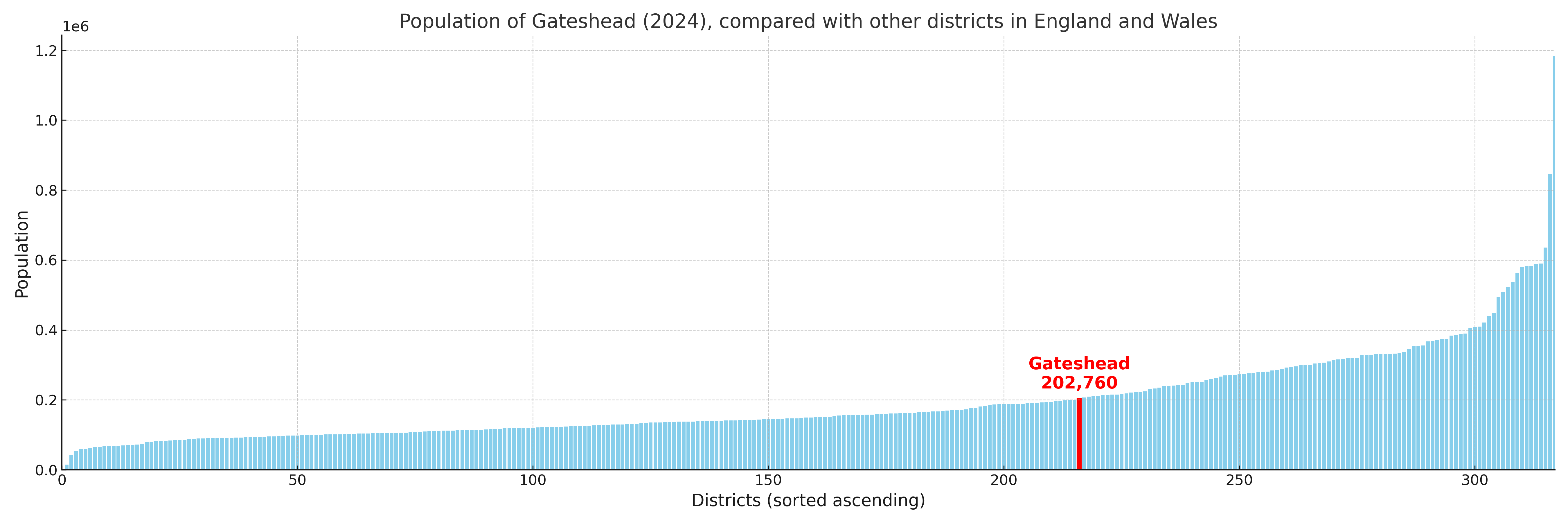
Gateshead compared with other districts in the UK
This section shows how Gateshead compares with other local authority districts in the UK, using a variety of measures and rankings.
Gateshead has 22 electoral wards.

Gateshead has a population of 202,760 (2024 mid-year estimate by ONS)
Population and Migration Trends in Gateshead
This chart shows the population trend for Gateshead from 2015 to 2024. It provides a quick overview of whether the local authority is growing, stable, or declining over time, and helps set context for the migration patterns shown below.
Population change is influenced by natural change (births minus deaths) and migration. The net migration chart below focuses on migration, separating internal migration (moves within the UK) from international migration (moves to and from abroad). Positive values indicate net inflows, while negative values indicate net outflows. The rate labels (per 1,000 residents) help compare migration intensity across years, even when the population size changes.
More local statistics and data for Gateshead can be found on the ONS statistics for Gateshead.
Latest news about Gateshead
Use the search box, or suggested search phrases, below to find recent news, council updates, planning stories, housing developments, transport changes, public services news, local elections, community issues and other local developments related to Gateshead. Results may include coverage from UK national, regional and local news websites, as well as official public-sector and local democracy sources.
- Gateshead council
- Gateshead planning
- Gateshead local elections
- Gateshead housing
- Gateshead transport
- Gateshead regeneration
- Gateshead public services