Northumberland
§ This page gives an overview of the Northumberland local authority district, bringing together key facts, maps, and data to help you quickly understand the area. This is one of 361 LAD profiles on Baseview.
Overview ⁞ Northumberland is England’s northernmost ceremonial county, known for its dramatic landscapes, unspoiled coastline, and rich medieval history. It borders Scotland to the north and stretches from the Cheviot Hills to the North Sea. The area is home to iconic landmarks such as Hadrian’s Wall, Alnwick Castle, and Bamburgh Castle, along with market towns like Hexham and Morpeth. Much of the county remains rural and sparsely populated, offering expansive moorland and national park areas. Northumberland operates under a single unitary authority—Northumberland County Council—and maintains a strong local identity rooted in its border history and natural beauty.
Northumberland Boundary Map
This map shows the official boundary of the Northumberland local authority district, based on the latest geographic data published by the Office for National Statistics (ONS). It provides a clear view of the district’s extent and helps you understand how the area fits within the wider regional and national landscape.
Contains OS data © Crown copyright and database right 2025. Source: Office for National Statistics licensed under the Open Government Licence v3.0.
The administrative boundary of Northumberland can also be viewed on OpenStreetMap: District Boundary of Northumberland.
Key Facts about Northumberland
What region is Northumberland in? Northumberland is in the North East of England, a region within the UK.
What county is Northumberland in? Northumberland is in the county of Northumberland.
Is Northumberland a city? No, Northumberland is not a city. (Note: the UK has 76 officially designated cities.)
Who governs Northumberland? The local government for this district is: Northumberland County Council (Unitary Authority).
▶ Official website of Northumberland County Council 🔗 northumberland.gov.uk
Which police force covers Northumberland? Policing in Northumberland is provided by Northumbria Police 🔗 northumbria.police.uk, which serves 6 local authority districts: Gateshead ⁞ Newcastle upon Tyne ⁞ North Tyneside ⁞ Northumberland ⁞ South Tyneside ⁞ Sunderland.
Northumberland in International Geographies
In the International Territorial Levels (ITLs) hierarchy, Northumberland is within one of ITLs Level 2 area, Northumberland, Durham and Tyne & Wear, that contains the following 4 ITLs Level 3 areas:
(ITL 1) North East
(ITL 2) ⇒ Northumberland, Durham and Tyne & Wear
(ITL 3) ⇒⇒ Durham ⁞ Northumberland ⁞ Tyneside ⁞ Sunderland
The International Territorial Levels are used by OECD member countries for statistical purposes to classify administrative areas. We have this listable page for easy browsing of ITL names and codes: International Territorial Levels.
Constituencies in Northumberland
Northumberland is divided into 4 parliamentary constituencies, listed below in alphabetical order.
A constituency is a specific geographical area that elects one Member of Parliament (MP) to represent them in the House of Commons. The United Kingdom is divided into 650 parliamentary constituencies. We have this list page for easy browsing of all UK parliamentary constituencies: List of Constituencies.
Wards in Northumberland
Northumberland is divided into 66 wards, listed below in alphabetical order.
- Alnwick
- Amble
- Amble West with Warkworth
- Ashington Central
- Bamburgh
- Bedlington Central
- Bedlington East
- Bedlington West
- Bellingham
- Berwick East
- Berwick North
- Berwick West with Ord
- Bothal
- Bywell
- Choppington
- College
- Corbridge
- Cowpen
- Cramlington East
- Cramlington Eastfield
- Cramlington North
- Cramlington South East
- Cramlington Village
- Cramlington West
- Croft
- Druridge Bay
- Haltwhistle
- Hartley
- Haydon
- Haydon and Hadrian
- Hexham Central with Acomb
- Hexham East
- Hexham West
- Hirst
- Holywell
- Humshaugh
- Isabella
- Kitty Brewster
- Longhorsley
- Longhoughton
- Lynemouth
- Morpeth Kirkhill
- Morpeth North
- Morpeth Stobhill
- Newbiggin Central and East
- Newsham
- Norham and Islandshires
- Pegswood
- Plessey
- Ponteland East and Stannington
- Ponteland North
- Ponteland South with Heddon
- Ponteland West
- Prudhoe North
- Prudhoe South
- Rothbury
- Seaton with Newbiggin West
- Seghill with Seaton Delaval
- Shilbottle
- Sleekburn
- South Blyth
- South Tynedale
- Stakeford
- Stocksfield and Broomhaugh
- Wensleydale
- Wooler
In the UK, a ward is a subdivision of a local authority area, used mainly for electoral and statistical purposes. Defined by the ONS, wards represent the primary unit for local elections, each returning one or more councillors to the local council. Wards are also used as a key geography for presenting population and census data. We have this list page for easy browsing of all electoral wards: List of all Electoral Wards in the UK.
Parishes in Northumberland
Northumberland is part-parished: 164 civil parishes (listed A-Z below) alongside 1 unparished areas.
- Acklington
- Acomb
- Adderstone with Lucker
- Akeld
- Allendale
- Alnham
- Alnmouth
- Alnwick
- Alwinton
- Amble by the Sea
- Ancroft
- Ashington
- Bamburgh
- Bardon Mill
- Bavington
- Beadnell
- Belford
- Bellingham
- Belsay
- Berwick-upon-Tweed
- Bewick
- Biddlestone
- Birtley
- Blanchland
- Blyth
- Bowsden
- Branxton
- Brinkburn
- Broomhaugh and Riding
- Bywell
- Callaly
- Capheaton
- Carham
- Chatton
- Chillingham
- Chollerton
- Choppington
- Coanwood
- Corbridge
- Cornhill-on-Tweed
- Corsenside
- Cramlington
- Craster
- Cresswell
- Denwick
- Doddington
- Duddo
- Earle
- East Bedlington
- East Chevington
- Edlingham
- Eglingham
- Ellingham
- Ellington and Linton
- Elsdon
- Embleton
- Ewart
- Falstone
- Featherstone
- Felton
- Ford
- Glanton
- Greenhead
- Greystead
- Haltwhistle
- Harbottle
- Hartburn
- Hartleyburn
- Hauxley
- Haydon
- Healey
- Hebron
- Heddon-on-the-Wall
- Hedgeley
- Hedley
- Henshaw
- Hepple
- Hepscott
- Hesleyhurst
- Hexham
- Hexhamshire
- Hollinghill
- Holy Island
- Horncliffe
- Horsley
- Humshaugh
- Ilderton
- Ingram
- Kielder
- Kilham
- Kirknewton
- Kirkwhelpington
- Knaresdale with Kirkhaugh
- Kyloe
- Lesbury
- Lilburn
- Longframlington
- Longhirst
- Longhorsley
- Longhoughton
- Lowick
- Lynemouth
- Matfen
- Meldon
- Melkridge
- Middleton
- Milfield
- Mitford
- Morpeth
- Netherton
- Netherwitton
- Newbiggin by the Sea
- Newbrough
- Newton-by-the-Sea
- Newton-on-the-Moor and Swarland
- Norham
- North Sunderland
- Nunnykirk
- Ord
- Otterburn
- Ovingham
- Ovington
- Pegswood
- Plenmeller with Whitfield
- Ponteland
- Prudhoe
- Rennington
- Rochester
- Roddam
- Rothbury
- Rothley
- Sandhoe
- Seaton Valley
- Shilbottle
- Shoreswood
- Shotley Low Quarter
- Simonburn
- Slaley
- Snitter
- Stamfordham
- Stannington
- Stocksfield
- Tarset
- Thirlwall
- Thirston
- Thropton
- Togston
- Tritlington and West Chevington
- Ulgham
- Wall
- Wallington Demesne
- Warden
- Wark
- Warkworth
- West Allen
- West Bedlington
- Whalton
- Whittingham
- Whittington
- Whitton and Tosson
- Widdrington Station and Stobswood
- Widdrington Village
- Wooler
- Wylam
A civil parish is the lowest tier of local government in England, used for villages, small towns, and suburbs. They have their own local authority, either a parish council or a parish meeting, which provides local services like managing parks, allotments, and streetlights, and represents the community's views to larger councils.
We have this list page for easy browsing of all parishes: List of Civil Parishes in England and Wales.
Post Towns in Northumberland
Below is a list of post towns in Northumberland, grouped by postcode area:
- NE ▸ Alnwick (NE66) ⁞ Ashington (NE63) ⁞ Bamburgh (NE66 / NE69) ⁞ Bedlington (NE22) ⁞ Belford (NE70) ⁞ Blyth (NE24) ⁞ Chathill (NE67) ⁞ Choppington (NE62) ⁞ Corbridge (NE45) ⁞ Cramlington (NE23) ⁞ Haltwhistle (NE49) ⁞ Hexham (NE46 / NE47 / NE48) ⁞ Morpeth (NE61 / NE65) ⁞ Newbiggin-by-the-Sea (NE64) ⁞ Prudhoe (NE42) ⁞ Riding Mill (NE44) ⁞ Seahouses (NE68) ⁞ Stocksfield (NE43) ⁞ Wooler (NE71) ⁞ Wylam (NE41)
- TD ▸ Berwick-upon-Tweed (TD15)
The UK postal hierarchy begins with broad postcode areas (such as “CB” or “M”), which are divided into smaller postcode districts (such as “CB8” or “M1”) to support accurate mail routing. Each postal address is anchored by a designated post town, the official locality name used in the UK postcode system, which operates independently from Local Authority Districts —the administrative boundaries used for council tax and local government services. Because they serve different purposes, a property’s postal address and its local authority district do not always align exactly.
Built-up Areas in Northumberland
Northumberland covers 83 built-up areas, listed below in alphabetical order.
- Acklington
- Acomb
- Allendale Town
- Alnwick
- Amble
- Ashington (Northumberland)
- Backworth *
- Bamburgh
- Beadnell
- Bedlington
- Belford
- Bellingham
- Berwick-upon-Tweed
- Blyth (Northumberland)
- Bomarsund
- Brunton
- Cambois
- Choppington
- Consett *
- Corbridge
- Cornhill on Tweed
- Cramlington
- Dudley (North Tyneside) *
- Ellington (Northumberland)
- Embleton
- Fair Moor
- Felton (Northumberland)
- Gilsland *
- Hadston
- Haggerston
- Haltwhistle
- Haydon Bridge
- Heddon-on-the-Wall
- Hepscott
- Hexham
- Hipsburn
- Horsley (Northumberland)
- Humshaugh
- Lesbury
- Loanend
- Longframlington
- Longhorsley
- Longhoughton
- Lowick
- Lynemouth
- Medburn
- Morpeth
- New Hartley
- Newbiggin-by-the-Sea
- Newton Hall
- Norham
- Ogle
- Otterburn
- Ouston
- Ovingham
- Pegswood
- Ponteland
- Prudhoe
- Redburn
- Riding Mill
- Rothbury
- Seahouses and North Sunderland
- Seaton Delaval
- Seaton Sluice *
- Seghill *
- Shilbottle
- South Broomhill
- Stakeford
- Stamfordham
- Stannington
- Stocksfield
- Swarland
- Throckley *
- Thropton
- Tranwell Woods
- Warkworth
- West Thirston
- Whittingham
- Widdrington Station
- Woodhorn
- Wooler
- Woolsington *
- Wylam
In the UK, a Built-up Area (BUA) is a continuous urban area of at least 20 hectares (0.2 km²), defined by the ONS as land where buildings are generally no more than 200 metres apart, such as towns, cities, or large villages. (Note: A BUA name marked with an asterisk (*) indicates that the area is situated partly in the district of Northumberland.)
We have this list page for easy browsing of all built-up areas: List of all Built-up Areas in GB.
Railway Stations in Northumberland
Northumberland is served by a number of National Rail stations, providing rail connections to nearby towns, cities, and destinations across Great Britain. The railway stations listed below are located within the Northumberland Local Authority District and are grouped by train operating company for clarity.
- London North Eastern Railway ▸ Berwick-Upon-Tweed (TD15 1NF)
- Northern Trains ▸ Morpeth (NE61 2SL) ⁞ Hexham (NE46 1EU) ⁞ Alnmouth (NE66 3QF) ⁞ Prudhoe (NE42 6NR) ⁞ Cramlington (NE23 9EX) ⁞ Ashington (NE63 9XE) ⁞ Wylam (NE41 8JA) ⁞ Haltwhistle (NE49 0AH) ⁞ Corbridge (NE45 5AY) ⁞ Seaton Delaval (NE25 0QX) ⁞ Stocksfield (NE43 7NQ) ⁞ Haydon Bridge (NE47 6LL) ⁞ Riding Mill (NE44 6EP) ⁞ Newsham (NE24 3QJ) ⁞ Bardon Mill (NE47 7HY) ⁞ Widdrington (NE61 5QH) ⁞ Chathill (NE67 5DE) ⁞ Pegswood (NE61 6SJ) ⁞ Acklington (NE65 4DE)
This is a district-level view only. For a complete list of all National Rail stations across Great Britain, see the UK National Rail Stations Directory.
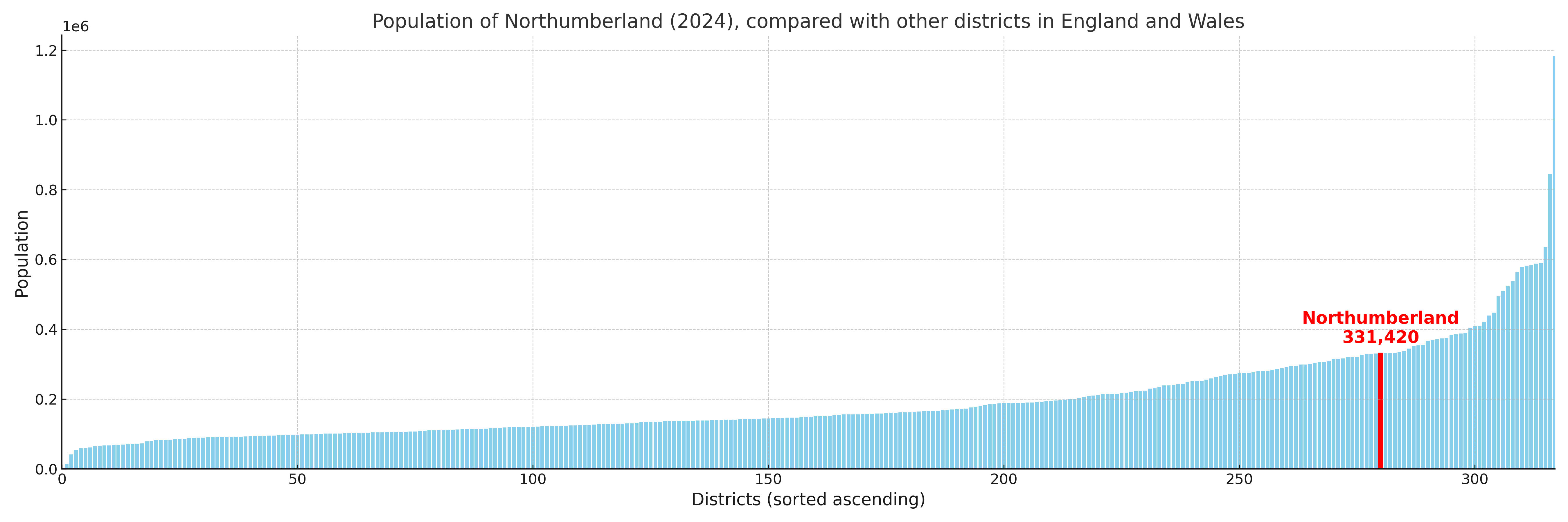
Northumberland compared with other districts in the UK
This section shows how Northumberland compares with other local authority districts in the UK, using a variety of measures and rankings.
Northumberland has 66 electoral wards.

Northumberland has a population of 331,420 (2024 mid-year estimate by ONS)
Population and Migration Trends in Northumberland
This chart shows the population trend for Northumberland from 2015 to 2024. It provides a quick overview of whether the local authority is growing, stable, or declining over time, and helps set context for the migration patterns shown below.
Population change is influenced by natural change (births minus deaths) and migration. The net migration chart below focuses on migration, separating internal migration (moves within the UK) from international migration (moves to and from abroad). Positive values indicate net inflows, while negative values indicate net outflows. The rate labels (per 1,000 residents) help compare migration intensity across years, even when the population size changes.
More local statistics and data for Northumberland can be found on the ONS statistics for Northumberland.
Latest news about Northumberland
Use the search box, or suggested search phrases, below to find recent news, council updates, planning stories, housing developments, transport changes, public services news, local elections, community issues and other local developments related to Northumberland. Results may include coverage from UK national, regional and local news websites, as well as official public-sector and local democracy sources.
- Northumberland council
- Northumberland planning
- Northumberland local elections
- Northumberland housing
- Northumberland transport
- Northumberland regeneration
- Northumberland public services