Belfast South and Mid Down
§ This page provides a baseview of UK constituency, bringing together various information and resources to help you better understand the area of Belfast South and Mid Down.
Overview ⁞ Belfast South and Mid Down is an area that blends city life with suburban tranquillity, covering parts of South Belfast and extending into scenic Down countryside. The urban section includes Queen’s University Belfast, Botanic Gardens, and the bustling Lisburn Road, known for boutiques and restaurants. Moving south, towns like Carryduff and Saintfield offer a more rural setting with rolling fields, historic churches, and traditional markets. Popular green spaces include Belvoir Forest Park and Minnowburn, perfect for walking and cycling. With both cultural landmarks and countryside charm, the constituency is ideal for those seeking variety in landscape and lifestyle.
Constituency Map and Boundary Information
Below is an interactive map showing the boundary of the Belfast South and Mid Down parliamentary constituency. The boundary data is sourced from the Office for National Statistics (ONS), using the latest official geographic definitions.
You can explore official statistics for this area on the ONS Explore Local Statistics page, or view its location on the UK Parliament constituency map.
Map tiles © OpenStreetMap contributors. Boundary data: Contains Ordnance Survey data © Crown copyright and database right 2024; Contains Office for National Statistics data © ONS 2024, licensed under the Open Government Licence v3.0.
Wards in Belfast South and Mid Down Constituency
There are 22 wards, listed below in alphabetical order.
- Beechill
- Belvoir
- Blackstaff
- Cairnshill
- Carryduff East
- Carryduff West
- Central
- Drumbo
- Finaghy
- Galwally
- Knockbracken
- Malone
- Moneyreagh
- Musgrave
- Newtownbreda
- Ormeau
- Ravenhill
- Rosetta
- Saintfield
- Stranmillis
- Upper Malone
- Windsor
Belfast South and Mid Down is a constituency that covers these wards in Belfast / Lisburn and Castlereagh / Newry, Mourne and Down.
Population by age group
Belfast South and Mid Down Population ⁞ The most recent data for constituencies in England and Wales comes from mid-year estimates for 2022. This tells us what the population was estimated to be on 30 June 2022.
| Age Band | Constituency (Number) | Constituency (%) | Northern Ireland (Number) | Northern Ireland (%) |
|---|---|---|---|---|
| 0 to 17 | 21,464 | 17.44% | 436,622 | 22.74% |
| 18 to 24 | 19,867 | 16.15% | 149,248 | 7.77% |
| 25 to 34 | 21,100 | 17.15% | 240,231 | 12.51% |
| 35 to 49 | 22,322 | 18.14% | 374,384 | 19.50% |
| 50 to 64 | 19,866 | 16.15% | 377,415 | 19.65% |
| 65 and over | 18,422 | 14.97% | 342,482 | 17.83% |
Population by ethnic group
Belfast South and Mid Down Ethnicity ⁞ The most recent census asked people about their ethnic group. The census was carried out in March 2021 in England, Wales and Northern Ireland and in March 2022 in Scotland.
| Ethnic Group | Constituency (Number) | Constituency (%) | Northern Ireland (%) |
|---|---|---|---|
| White | 106,386 | 88.99% | 96.55% |
| Chinese | 3,733 | 3.12% | 0.50% |
| Indian | 2,846 | 2.38% | 0.52% |
| Mixed | 1,776 | 1.49% | 0.76% |
| Black African | 1,592 | 1.33% | 0.42% |
| Other Asian | 1,104 | 0.92% | 0.28% |
| Arab | 524 | 0.44% | 0.10% |
| Filipino | 474 | 0.40% | 0.23% |
| Other ethnicities | 452 | 0.38% | 0.19% |
| Pakistani | 265 | 0.22% | 0.08% |
| Black Other | 187 | 0.16% | 0.16% |
| Roma | 162 | 0.14% | 0.08% |
| Irish Traveller | 46 | 0.04% | 0.14% |
Belfast South and Mid Down compared with other constituencies
Belfast South and Mid Down has a population of 123,041 (2024 mid-year estimate by ONS). The population of the UK is 69,281,400 as of mid-2024. There are 650 constituencies, so the average population per constituency is around 106,600.
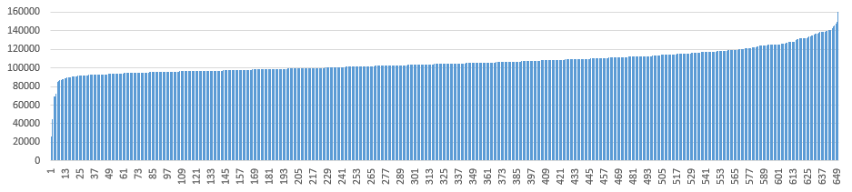
Compared with the other 649 constituencies, Belfast South and Mid Down has a population higher than 572, lower than 48, and similar to 30 constituencies (±2,500, including itself).
Latest news about Belfast South and Mid Down
Use the search box or suggested search phrases below to find recent news, local updates, election coverage, public services stories, planning issues, transport updates and community developments related to Belfast South and Mid Down. Results may include coverage from UK national, regional and local news websites, as well as trusted public-interest sources.
- Belfast South and Mid Down constituency
- Belfast South and Mid Down election
- Belfast South and Mid Down MP